Wyoming - Natrona County - Historic Districts
Natrona County Wyoming (Historic Districts) has 7 places on the National Register of Historic Places including 3 places of National significance and 2 places of Statewide significance. Significant places include Fort Caspar, Fort Caspar (Boundary Decrease), Fort Caspar (Boundary Increase), Casper Army Air Base and South Wolcott Street Historic District.

The famous person Patrick Sullivan is associated with one of more of the Natrona County historic places.

Some of the country's most noteable architects helped create the Natrona County places including Louis Guinard and US ARMY. Prominent architectural styles found in Natrona Country are Colonial Revival, Late 19th And 20th Century Revivals and Late 19th And Early 20th Century American Movements.

Casper Army Air Base (added 2001 - - #01000789)
Also known as Natrona County International Airport, Casper Army Air Field
8500 Fuller St. , Casper
Bwmoll3, Public domain, via Wikimedia Commons
Historic Significance:
Event
Area of Significance:
Art, Military
Period of Significance:
1925-1949
Owner:
Local
Historic Function:
Defense
Historic Sub-function:
Military Facility
Current Function:
Transportation
Current Sub-function:
Air-Related
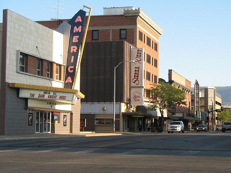
Casper Downtown Historic District (added 2016 - - #16000732)
Casper, Casper
Zibodiz, CC BY-SA 3.0, via Wikimedia Commons
Historic Significance:
Event
Area of Significance:
Architecture, Commerce
Period of Significance:
1896-1970 AD
Fort Caspar (added 1971 - - #71000887)
Also known as See Also:Fort Caspar (Boundary Decrease);Fort Caspar (Bounda
14 Fort Caspar Rd. , Casper
Historic Significance:
Event, Information Potential
Area of Significance:
Historic - Non-Aboriginal, Military, Transportation, Commerce, Communications, Social History
Cultural Affiliation:
19th Century American
Period of Significance:
1850-1874
Owner:
Local
Historic Function:
Defense
Historic Sub-function:
Military Facility
Current Function:
Landscape, Recreation And Culture
Current Sub-function:
Museum, Park
Fort Caspar (Boundary Decrease) (added 1976 - - #71001094)
Also known as See Also:Fort Caspar;Fort Caspar (Boundary Increase)
S central area of fort , Casper
send us a photo to share
Historic Significance:
Event
Area of Significance:
Transportation, Military, Commerce, Communications, Social History
Period of Significance:
1850-1874
Owner:
Local
Historic Function:
Defense
Historic Sub-function:
Military Facility
Current Function:
Landscape
Current Sub-function:
Underwater
Fort Caspar (Boundary Increase) (added 1976 - - #76002282)
Also known as Platte Bridge Station;See Also:Fort Caspar;Fort Caspar (Boun
Area on N side of fort along Platte River , Casper
send us a photo to share
Historic Significance:
Information Potential, Architecture/Engineering
Architect, builder, or engineer:
Guinard,Louis
Architectural Style:
Other
Area of Significance:
Historic - Non-Aboriginal, Transportation, Engineering
Cultural Affiliation:
19th Century American
Period of Significance:
1850-1874
Owner:
Private
Historic Function:
Transportation
Historic Sub-function:
Road-Related
Current Function:
Landscape
Current Sub-function:
Park
Pathfinder Dam Historic District (added 2015 - - #15000357)
Alcova, Alcova
Flickr upload bot, CC BY 2.0, via Wikimedia Commons
Historic Significance:
Event, Architecture/Engineering
Architectural Style:
Other
Area of Significance:
Engineering, Agriculture
Period of Significance:
1900-1949 AD
South Wolcott Street Historic District (added 1988 - - #88002609)
Roughly bounded by S. Center St., E. Ninth St., S. Wolcott St., E. Seventh St., S. Beech St., and E. Thirteenth St. , Casper
Drmccreedy, CC BY-SA 4.0, via Wikimedia Commons
Historic Significance:
Person, Event
Historic Person:
Sullivan,Patrick,et al.
Area of Significance:
Community Planning And Development, Other, Agriculture
Period of Significance:
1925-1949, 1900-1924
Owner:
Private
Historic Function:
Domestic
Historic Sub-function:
Multiple Dwelling, Single Dwelling
Current Function:
Domestic
Current Sub-function:
Multiple Dwelling, Single Dwelling
Return to Top
Select a Different Wyoming County (map)
Albany
Big Horn
Carbon
Converse
Crook
Fremont
Goshen
Hot Springs
Johnson
Laramie
Lincoln
Natrona
Niobrara
Park
Platte
Sheridan
Sublette
Sweetwater
Teton
Uinta
Washakie
Weston
Select a Different State (map)
Alabama
Alaska
Arizona
Arkansas
California
Colorado
Connecticut
Delaware
District Of Columbia
Florida
Georgia
Hawaii
Idaho
Illinois
Indiana
Iowa
Kansas
Kentucky
Louisiana
Maine
Maryland
Massachusetts
Michigan
Minnesota
Mississippi
Missouri
Montana
Nebraska
Nevada
New Hampshire
New Jersey
New Mexico
New York
North Carolina
North Dakota
Ohio
Oklahoma
Oregon
Pennsylvania
Rhode Island
South Carolina
South Dakota
Tennessee
Texas
Utah
Vermont
Virginia
Washington
West Virginia
Wisconsin
Wyoming
Return to Home Page