Utah - Washington County
Washington County Utah has 50 places on the National Register of Historic Places including 3 places of National significance and 28 places of Statewide significance. Significant places include Hamblin, Jacob, House, Mountain Meadows Historic Site, Old Washington County Courthouse, Angels Landing Trail--West Rim Trail and Cable Mountain Draw Works.

Many famous people are associated with these Washington County historic places including Jacob Hamblin, Robert D. Covington, Joseph H. Frisby, Jepson, James, Jr. and Thomas Judd.

Some of the country's most noteable architects helped create the Washington County places including NPS, Civilian Conservation Corps, Harry Langley, Guy D. Edwards, Richard Watkins, Elijah Averett, T.C. Vint, John E. Anderson, Elisha Averett and F.A. Kittredge. Prominent architectural styles found in Washington Country are Late Victorian, Greek Revival and Bungalow/Craftsman.

Angels Landing Trail--West Rim Trail (added 1987 - - #86003707)
S of Scout Lookout across the Virgin River and Refrigerator Canyon , Springdale
Clpo13, Public domain, via Wikimedia Commons
Historic Significance:
Architecture/Engineering
Architect, builder, or engineer:
Et. al, Vint,T.C.
Area of Significance:
Landscape Architecture
Period of Significance:
1925-1949
Owner:
Federal
Historic Function:
Recreation And Culture, Transportation
Historic Sub-function:
Outdoor Recreation, Pedestrian Related
Current Function:
Recreation And Culture, Transportation
Current Sub-function:
Outdoor Recreation, Pedestrian Related
More Information:
Blake, Wallace, House (added 1978 - - #78002709)
S of St. George , St. George
Jarenblake, CC BY-SA 3.0, via Wikimedia Commons
Historic Significance:
Architecture/Engineering
Architect, builder, or engineer:
Wiethen,Dode
Architectural Style:
No Style Listed
Area of Significance:
Architecture
Period of Significance:
1900-1924
Owner:
Private
Historic Function:
Domestic
Historic Sub-function:
Single Dwelling
Current Function:
Vacant/Not In Use
More Information:
Bradshaw House--Hotel (added 1991 - - #91001443)
85 S. Main St. , Hurricane
Ntsimp, CC0, via Wikimedia Commons
Historic Significance:
Event
Area of Significance:
Commerce, Exploration/Settlement, Community Planning And Development
Period of Significance:
1925-1949, 1900-1924
Owner:
Local
Historic Function:
Domestic, Education
Historic Sub-function:
Hotel, School, Single Dwelling
Current Function:
Vacant/Not In Use
More Information:
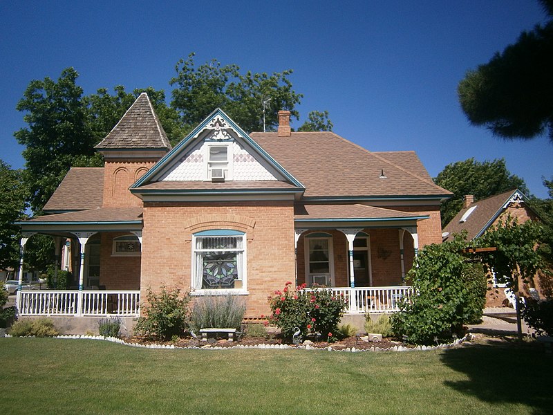
Butler, William F., House (added 1984 - - #84002433)
168 S. 300 West , St. George
JoannaPoe, CC BY-SA 4.0, via Wikimedia Commons
Historic Significance:
Person, Architecture/Engineering
Architect, builder, or engineer:
Unknown
Architectural Style:
Late Victorian
Historic Person:
Frisby,Joseph H.
Significant Year:
1906
Area of Significance:
Politics/Government, Architecture
Period of Significance:
1900-1924
Owner:
Private
Historic Function:
Domestic
Historic Sub-function:
Single Dwelling
Current Function:
Commerce/Trade
More Information:
Cable Creek Bridge (added 1996 - - #96000053)
Also known as RT-0996J;1590-009P (Federal Highways Dept.)
Floor of the Valley Rd. at milepost 4.48, S of Weeping Rock Parking Area entrance , Springdale
Acroterion, Public domain, via Wikimedia Commons
Historic Significance:
Architecture/Engineering, Event
Architect, builder, or engineer:
Burea of Public Roads, Merrit, Chapman and Scott Inc.
Architectural Style:
Other
Area of Significance:
Architecture, Landscape Architecture
Period of Significance:
1925-1949
Owner:
Federal
Historic Function:
Landscape, Transportation
Historic Sub-function:
Park, Road-Related
Current Function:
Landscape, Transportation
Current Sub-function:
Park, Road-Related
More Information:
Cable Mountain Draw Works (added 1978 - - #78000281)
N of Springdale in Zion National Park , Springdale
Acroterion, Public domain, via Wikimedia Commons
Historic Significance:
Event, Architecture/Engineering
Architect, builder, or engineer:
Flanagen,David
Area of Significance:
Engineering, Commerce, Invention
Period of Significance:
1925-1949, 1900-1924
Owner:
Federal
Historic Function:
Industry/Processing/Extraction
Historic Sub-function:
Extractive Facility
Current Function:
Landscape
Current Sub-function:
Park
More Information:
Canyon Overlook Trail (added 1987 - - #86003722)
Across hwy. from parking area at E end of Zion-Mt. Carmel Tunnel to a point directly above the Great Arch of Zion , Springdale
Acroterion, Public domain, via Wikimedia Commons
Historic Significance:
Architecture/Engineering
Architect, builder, or engineer:
Civilian Conservation Corps, Langley,Harry
Area of Significance:
Landscape Architecture
Period of Significance:
1925-1949
Owner:
Federal
Historic Function:
Recreation And Culture, Transportation
Historic Sub-function:
Outdoor Recreation, Pedestrian Related
Current Function:
Recreation And Culture, Transportation
Current Sub-function:
Outdoor Recreation, Pedestrian Related
More Information:
Covington, Robert D., House (added 1978 - - #78002711)
200 N. 200 East , Washington
Cropbot, Public domain, via Wikimedia Commons
Historic Significance:
Person, Architecture/Engineering
Architect, builder, or engineer:
Averett,Elisha, Averett,Elijah
Architectural Style:
No Style Listed
Historic Person:
Covington,Robert D.
Significant Year:
1859
Area of Significance:
Exploration/Settlement, Architecture, Religion
Period of Significance:
1850-1874
Owner:
Private
Historic Function:
Domestic
Historic Sub-function:
Single Dwelling
Current Function:
Domestic
Current Sub-function:
Single Dwelling
More Information:
Crawford Irrigation Canal (added 1987 - - #86003732)
W bank of Virgin River from 1 mi. N of Virgin River Bridge to base of Virgin River Formation and .5 mi up Oak Creek , Springdale
Acroterion, Public domain, via Wikimedia Commons
Historic Significance:
Event
Area of Significance:
Exploration/Settlement
Period of Significance:
1900-1924, 1875-1899
Owner:
Federal
Historic Function:
Industry/Processing/Extraction
Historic Sub-function:
Water Works
Current Function:
Vacant/Not In Use
More Information:
Deseret Telegraph and Post Office (added 1972 - - #72001263)
On UT 15 , Rockville
Cropbot, Public domain, via Wikimedia Commons
Historic Significance:
Event
Area of Significance:
Communications
Period of Significance:
1850-1874
Owner:
Private
Historic Function:
Domestic, Industry/Processing/Extraction
Historic Sub-function:
Communications Facility, Single Dwelling
Current Function:
Vacant/Not In Use
More Information:
East Entrance Checking Station (added 1987 - - #86003711)
Island in middle of UT 9 , Springdale
An Errant Knight, CC BY-SA 4.0, via Wikimedia Commons
Historic Significance:
Architecture/Engineering
Architect, builder, or engineer:
Civilian Conservation Corps
Architectural Style:
Other
Area of Significance:
Architecture
Period of Significance:
1925-1949
Owner:
Federal
Historic Function:
Other
Current Function:
Other
More Information:
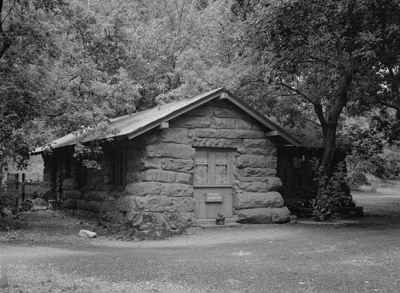
East Entrance Residence (added 1987 - - #86003712)
E Entrance 150 ft. N of UT 9 , Springdale
Acroterion, Public domain, via Wikimedia Commons
Historic Significance:
Architecture/Engineering
Architect, builder, or engineer:
Civilian Conservation Corps, NPS
Architectural Style:
Other
Area of Significance:
Architecture
Period of Significance:
1925-1949
Owner:
Federal
Historic Function:
Domestic
Historic Sub-function:
Institutional Housing
Current Function:
Domestic
Current Sub-function:
Institutional Housing
More Information:
East Entrance Sign (added 1987 - - #86003710)
East Entrance Checking Station on N and S sides of UT 9 , Springdale
Carnildo, CC BY 2.5, via Wikimedia Commons
Historic Significance:
Architecture/Engineering
Architect, builder, or engineer:
Civilian Conservation Corps
Architectural Style:
Other
Area of Significance:
Architecture
Period of Significance:
1925-1949
Owner:
Federal
Historic Function:
Recreation And Culture
Historic Sub-function:
Monument/Marker
Current Function:
Recreation And Culture
Current Sub-function:
Monument/Marker
More Information:
East Rim Trail (added 1987 - - #86003723)
Between Weeping Rock Parking Area and Observation Pt. , Springdale
Acroterion, Public domain, via Wikimedia Commons
Historic Significance:
Event, Architecture/Engineering
Architect, builder, or engineer:
NPS
Area of Significance:
Transportation, Landscape Architecture
Period of Significance:
1900-1924, 1875-1899
Owner:
Federal
Historic Function:
Recreation And Culture, Transportation
Historic Sub-function:
Outdoor Recreation, Pedestrian Related
Current Function:
Recreation And Culture, Transportation
Current Sub-function:
Outdoor Recreation, Pedestrian Related
More Information:
Emerald Pools Trail (added 1987 - - #86003725)
Foot Bridge across hwy. from Utah Parks Lodge proceeding W to the Lower Emerald Pool , Springdale
Acroterion, Public domain, via Wikimedia Commons
Historic Significance:
Architecture/Engineering
Architect, builder, or engineer:
Langley,Harry
Area of Significance:
Landscape Architecture
Period of Significance:
1925-1949
Owner:
Federal
Historic Function:
Recreation And Culture, Transportation
Historic Sub-function:
Outdoor Recreation, Road-Related
Current Function:
Recreation And Culture, Transportation
Current Sub-function:
Outdoor Recreation, Road-Related
More Information:
Enterprise Meetinghouse (added 1993 - - #93000410)
Also known as Young Men's Mutual Hall;Daughters of Utah Pioneers Building
Approximately 24 S. Center St. , Enterprise
send us a photo to share
Historic Significance:
Architecture/Engineering, Event
Architect, builder, or engineer:
Marshall, Wm. et al.
Architectural Style:
Other
Area of Significance:
Education, Religion, Architecture
Period of Significance:
1925-1949, 1900-1924, 1875-1899
Owner:
Local
Historic Function:
Education, Religion, Social
Historic Sub-function:
Meeting Hall, Religious Structure, School
Current Function:
Social
Current Sub-function:
Meeting Hall
More Information:
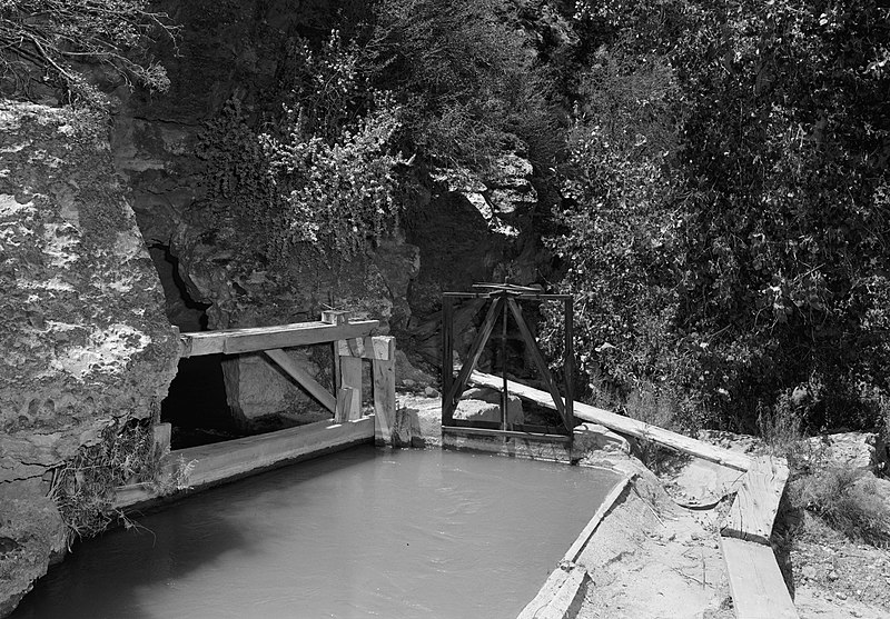
Flanigan Ditch (added 1998 - - #97001630)
Zion National Park , Springdale
Acroterion, Public domain, via Wikimedia Commons
Historic Significance:
Event, Information Potential
Area of Significance:
Social History, Exploration/Settlement, Historic - Non-Aboriginal, Agriculture
Cultural Affiliation:
Euro-American, Mormon Pioneer Settlement
Period of Significance:
1950-1974, 1925-1949, 1900-1924, 1875-1899
Owner:
Federal
Historic Function:
Agriculture/Subsistence
Historic Sub-function:
Irrigation Facility
Current Function:
Agriculture/Subsistence
Current Sub-function:
Irrigation Facility
More Information:
Floor of the Valley Road (added 1996 - - #96000048)
Also known as Floor of the Valley Highway;Zion Canyon Scenic Drive;Rt. 2;R
From jct. with Zion--Mt. Carmel Hwy. along the N. Fork of the Virgin R., Zion National Park , Springdale
Grzlbrmpft, Public domain, via Wikimedia Commons
Historic Significance:
Event, Architecture/Engineering
Architect, builder, or engineer:
Carnes, W.G., et al., Civilian Conservation Corps
Area of Significance:
Landscape Architecture, Architecture
Period of Significance:
1925-1949
Owner:
Federal
Historic Function:
Landscape, Transportation
Historic Sub-function:
Park, Road-Related
Current Function:
Landscape, Transportation
Current Sub-function:
Park, Road-Related
More Information:
Forsyth, Thomas, House (added 1982 - - #82004184)
Off UT 15 , Toquerville
Ntsimp, CC0, via Wikimedia Commons
Historic Significance:
Event, Architecture/Engineering
Architect, builder, or engineer:
Forsyth,Thomas
Architectural Style:
No Style Listed
Area of Significance:
Exploration/Settlement, Architecture
Period of Significance:
1850-1874
Owner:
Private
Historic Function:
Domestic
Historic Sub-function:
Single Dwelling
Current Function:
Domestic
Current Sub-function:
Single Dwelling
More Information:
Fort Harmony Site (added 1979 - - #79003493)
E of New Harmony on I-15 , New Harmony
Kolobcoyote, CC BY-SA 4.0, via Wikimedia Commons
Historic Significance:
Event
Area of Significance:
Exploration/Settlement
Period of Significance:
1850-1874
Owner:
Private
Historic Function:
Defense, Domestic
Historic Sub-function:
Fortification
Current Function:
Landscape
Current Sub-function:
Underwater
More Information:
Fort Pearce (added 1975 - - #75001834)
12 mi. SE of Washington off I-15 , Washington
Thesixdees, CC BY-SA 3.0, via Wikimedia Commons
Historic Significance:
Event
Area of Significance:
Agriculture, Military
Period of Significance:
1850-1874
Owner:
Federal
Historic Function:
Agriculture/Subsistence, Defense
Historic Sub-function:
Fortification
Current Function:
Recreation And Culture
Current Sub-function:
Museum
More Information:
Gateway to the Narrows Trail (added 1987 - - #86003726)
Temple of Sinawava at the end of Zion Canyon Scenic Dr. to a pt. 1 mi. N on Virgin River , Springdale
Martin H., Public domain, via Wikimedia Commons
Historic Significance:
Event, Architecture/Engineering
Architect, builder, or engineer:
Ruesch,Walter, Edwards,Guy D.
Area of Significance:
Transportation, Landscape Architecture
Period of Significance:
1925-1949
Owner:
Federal
Historic Function:
Recreation And Culture, Transportation
Historic Sub-function:
Outdoor Recreation, Pedestrian Related
Current Function:
Recreation And Culture, Transportation
Current Sub-function:
Outdoor Recreation, Pedestrian Related
More Information:
Graff, George and Bertha, House (added 1998 - - #98001461)
2865 Santa Clara Dr. , Santa Clara
Muhandis5, CC BY-SA 3.0, via Wikimedia Commons
Historic Significance:
Architecture/Engineering, Event
Architect, builder, or engineer:
Graff, George A.
Architectural Style:
Other, Mid 19th Century Revival
Area of Significance:
Architecture, Social History
Period of Significance:
1925-1949, 1900-1924
Owner:
Private
Historic Function:
Domestic
Historic Sub-function:
Single Dwelling
Current Function:
Commerce/Trade
Current Sub-function:
Specialty Store
More Information:
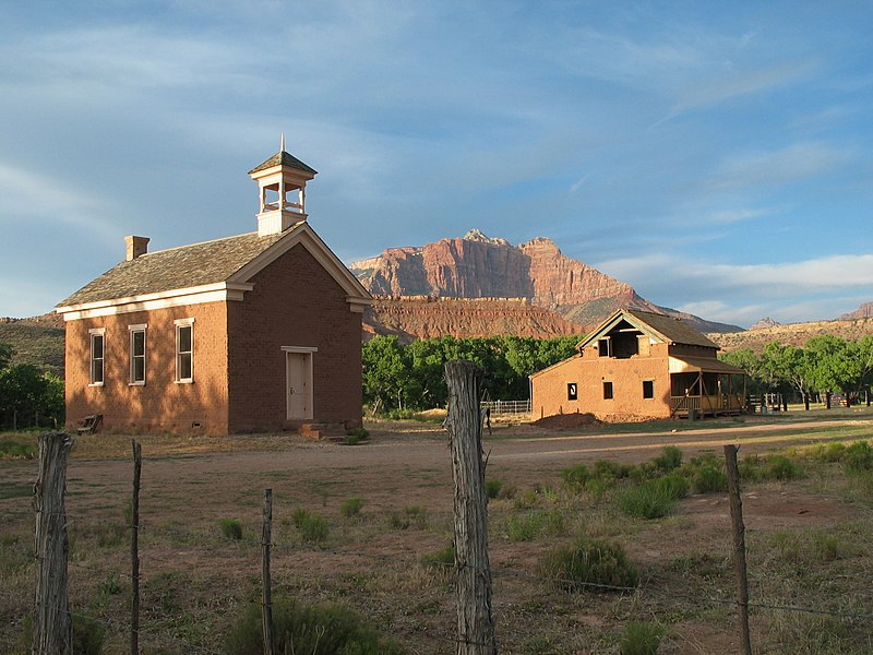
Grafton Historic District (added 2010 - - #10000732)
Beginning at Hall and Grafton Ditch and the Grafton to Rockville Rd, Rockville
Jonesey, Public domain, via Wikimedia Commons
Historic Significance:
Event
Area of Significance:
Exploration/Settlement, Agriculture
Period of Significance:
1925-1949, 1900-1924, 1875-1899, 1850-1874
Grafton Historic District (added 1999 - - #99001007)
1861 townsite of Grafton , Rockville
send us a photo to share
Historic Significance:
Event
Area of Significance:
Exploration/Settlement, Community Planning And Development, Agriculture, Architecture
Period of Significance:
1925-1949, 1900-1924, 1875-1899, 1850-1874
Owner:
Local, Private
Historic Function:
Agriculture/Subsistence, Domestic, Education, Religion
Historic Sub-function:
Animal Facility, Religious Structure, School, Single Dwelling, Storage
Current Function:
Vacant/Not In Use
Grotto Camping Ground North Comfort Station (added 1987 - - #86003705)
Grotto Picnic Area near Grotto Residence E of Scenic Dr. , Springdale
Acroterion, Public domain, via Wikimedia Commons
Historic Significance:
Architecture/Engineering
Architect, builder, or engineer:
Langley,Harry
Architectural Style:
Other
Area of Significance:
Architecture
Period of Significance:
1925-1949
Owner:
Federal
Historic Function:
Other
Current Function:
Other
More Information:
Grotto Camping Ground South Comfort Station (added 1987 - - #86003704)
Grotto Picnic Area near Grotto Residence, E of Scenic Dr. , Springdale
Acroterion, Public domain, via Wikimedia Commons
Historic Significance:
Architecture/Engineering
Architect, builder, or engineer:
NPS
Architectural Style:
Other
Area of Significance:
Architecture
Period of Significance:
1925-1949
Owner:
Federal
Historic Function:
Other
Current Function:
Other
More Information:
Grotto Trail (added 1996 - - #86003914)
Zion National Park, 120 ft. N of Zion Lodge extending S .2 mi. parallel to the E side of Zion Canyon Scenic Dr. , Springdale
Acroterion, Public domain, via Wikimedia Commons
Historic Significance:
Architecture/Engineering
Architectural Style:
No Style Listed
Area of Significance:
Landscape Architecture
Period of Significance:
1925-1949
Owner:
Federal
Historic Function:
Recreation And Culture, Transportation
Historic Sub-function:
Outdoor Recreation, Pedestrian Related
Current Function:
Recreation And Culture, Transportation
Current Sub-function:
Outdoor Recreation, Pedestrian Related
More Information:
Hafen, Hans George, House (added 1998 - - #98001462)
3003 Santa Clara Dr. , Santa Clara
Muhandis5, CC BY-SA 3.0, via Wikimedia Commons
Historic Significance:
Event, Architecture/Engineering
Architect, builder, or engineer:
Hafen, Hans George
Architectural Style:
Late Victorian, Other
Area of Significance:
Architecture, Social History
Period of Significance:
1925-1949, 1900-1924, 1875-1899, 1850-1874
Owner:
Private
Historic Function:
Domestic
Historic Sub-function:
Single Dwelling
Current Function:
Domestic
Current Sub-function:
Single Dwelling
More Information:
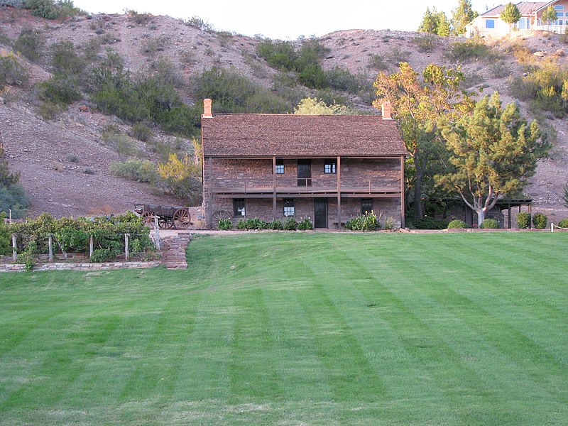
Hamblin, Jacob, House (added 1971 - - #71000860)
US 91 , Santa Clara
AliveFreeHappy, CC BY-SA 3.0, via Wikimedia Commons
Historic Significance:
Person
Historic Person:
Hamblin,Jacob
Significant Year:
1863
Area of Significance:
Religion
Cultural Affiliation:
Mormon, Mormons
Period of Significance:
1850-1874
Owner:
State
Historic Function:
Domestic
Historic Sub-function:
Single Dwelling
Current Function:
Recreation And Culture
Current Sub-function:
Museum
More Information:
Hidden Canyon Trail (added 1987 - - #86003731)
Hidden Canyon jct. on the E Rim Trail to the mouth of Hidden Canyon , Springdale
Sylfred1977, CC BY 2.0, via Wikimedia Commons
Historic Significance:
Architecture/Engineering
Architect, builder, or engineer:
Kittredge,F.A., Edwards,Guy D.
Area of Significance:
Landscape Architecture
Period of Significance:
1925-1949
Owner:
Federal
Historic Function:
Recreation And Culture, Transportation
Historic Sub-function:
Outdoor Recreation, Pedestrian Related
Current Function:
Recreation And Culture, Transportation
Current Sub-function:
Outdoor Recreation, Pedestrian Related
More Information:
Hurricane Canal (added 1977 - - #77001324)
E of Hurricane , Hurricane
Cropbot, Public domain, via Wikimedia Commons
Historic Significance:
Event, Architecture/Engineering
Architect, builder, or engineer:
Multiple
Area of Significance:
Agriculture, Engineering
Period of Significance:
1900-1924
Owner:
Private
Historic Function:
Agriculture/Subsistence, Industry/Processing/Extraction
Historic Sub-function:
Water Works
Current Function:
Agriculture/Subsistence, Industry/Processing/Extraction
Current Sub-function:
Water Works
More Information:
Hurricane High School (added 2005 - - #86000752)
34 S. One Hundred W , Hurricane
send us a photo to share
Historic Significance:
Event, Architecture/Engineering
Architect, builder, or engineer:
Anderson,John E.
Architectural Style:
Prairie School, Moderne
Area of Significance:
Politics/Government, Architecture, Social History
Period of Significance:
1925-1949
Owner:
Local
Historic Function:
Education
Historic Sub-function:
School
Current Function:
Education
Current Sub-function:
School
Hurricane Historic District (added 1995 - - #95000980)
Also known as See also:91001443;77001324;86000752;91001444;93000063;920016
Roughly bounded by 300 South, 200 West, State St. and the Hurricane Canal , Hurricane
Ntsimp, CC0, via Wikimedia Commons
Historic Significance:
Architecture/Engineering, Event
Architectural Style:
Late Victorian, Other, Bungalow/Craftsman
Area of Significance:
Agriculture, Exploration/Settlement, Social History, Community Planning And Development
Period of Significance:
1925-1949, 1900-1924
Owner:
Local, Private
Historic Function:
Agriculture/Subsistence, Commerce/Trade, Domestic, Education
Historic Sub-function:
Department Store, Library, Multiple Dwelling, School, Single Dwelling, Storage
Current Function:
Agriculture/Subsistence, Commerce/Trade, Domestic, Education
Current Sub-function:
Department Store, Library, Multiple Dwelling, School, Single Dwelling, Storage
More Information:
Hurricane Library--City Hall (added 1991 - - #91001444)
35 W. State St. , Hurricane
Ntsimp, CC0, via Wikimedia Commons
Historic Significance:
Event
Area of Significance:
Politics/Government, Social History
Period of Significance:
1925-1949
Owner:
Local
Historic Function:
Education, Government
Historic Sub-function:
City Hall, Library
Current Function:
Recreation And Culture
Current Sub-function:
Museum
More Information:
Hurricane--LaVerkin Bridge (added 1995 - - #95000413)
Also known as Hot Springs Bridge
E of UT 9 over the Virgin R. , Hurricane
Cropbot, Public domain, via Wikimedia Commons
Historic Significance:
Event, Architecture/Engineering
Architect, builder, or engineer:
Midland Bridge Company
Architectural Style:
No Style Listed
Area of Significance:
Transportation, Engineering
Period of Significance:
1925-1949, 1900-1924
Owner:
Local
Historic Function:
Transportation
Historic Sub-function:
Road-Related
Current Function:
Transportation
Current Sub-function:
Pedestrian Related
More Information:
Isom, Samuel and Elizabeth, House (added 1993 - - #93000063)
Also known as Bishop Isom House
188 S. 100 West , Hurricane
Ntsimp, CC0, via Wikimedia Commons
Historic Significance:
Architecture/Engineering, Event
Architect, builder, or engineer:
A.Y. Milne & Sons
Architectural Style:
Other, Late Victorian
Area of Significance:
Social History, Architecture
Period of Significance:
1900-1924
Owner:
Private
Historic Function:
Domestic
Historic Sub-function:
Single Dwelling
Current Function:
Domestic
Current Sub-function:
Single Dwelling
More Information:
Jepson, James, Jr., House (added 2000 - - #00000732)
15 East Jepson , Virgin
Anuzman1, CC BY-SA 4.0, via Wikimedia Commons
Historic Significance:
Architecture/Engineering, Person
Historic Person:
Jepson, James, Jr.
Significant Year:
1877
Area of Significance:
Architecture, Social History, Exploration/Settlement
Period of Significance:
1925-1949, 1900-1924, 1875-1899
Owner:
Private
Historic Function:
Domestic
Historic Sub-function:
Single Dwelling
Current Function:
Domestic
Current Sub-function:
Single Dwelling
More Information:
Judd, Thomas, House (added 1978 - - #78002710)
Also known as Judd-Miles House
269 S. 200 East , St. George
KLOTZPLATE, CC BY-SA 4.0, via Wikimedia Commons
Historic Significance:
Person, Architecture/Engineering
Architect, builder, or engineer:
Judd,Thomas
Architectural Style:
Other
Historic Person:
Judd,Thomas
Significant Year:
1876
Area of Significance:
Exploration/Settlement, Agriculture, Architecture
Period of Significance:
1875-1899
Owner:
Private
Historic Function:
Domestic
Historic Sub-function:
Single Dwelling
Current Function:
Domestic
Current Sub-function:
Single Dwelling
More Information:
Leavitt, Lemuel and Mary Ann, House (added 1999 - - #99000215)
1408 Quail , Santa Clara
Ntsimp, CC0, via Wikimedia Commons
Historic Significance:
Event
Area of Significance:
Social History
Period of Significance:
1925-1949, 1900-1924
Owner:
Private
Historic Function:
Domestic
Historic Sub-function:
Single Dwelling
Current Function:
Domestic
Current Sub-function:
Single Dwelling
More Information:
Leeds CCC Camp Historic District (added 1993 - - #93000062)
Also known as CCC Co. 585,Camp Leeds,SCS-7;Site No. 42WS2394
96 W. Mulberry , Leeds
Kneumann78, CC BY-SA 4.0, via Wikimedia Commons
Historic Significance:
Event
Area of Significance:
Conservation, Social History
Period of Significance:
1925-1949, 1900-1924
Owner:
Private
Historic Function:
Domestic, Government, Health Care
Historic Sub-function:
Clinic, Institutional Housing
Current Function:
Work In Progress
More Information:
Leeds Tithing Office (added 1985 - - #85000291)
SW Corner 100 West and 100 North , Leeds
Ntsimp, CC0, via Wikimedia Commons
Historic Significance:
Event
Area of Significance:
Social History
Period of Significance:
1875-1899
Owner:
Private
Historic Function:
Religion, Social
Historic Sub-function:
Civic
Current Function:
Vacant/Not In Use
More Information:
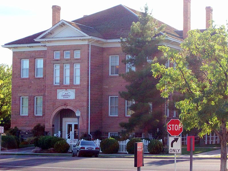
Main Building of Dixie College (added 1980 - - #80003988)
Also known as Southwestern Utah Arts Center
86 S. Main St. , St. George
SreeBot, CC BY-SA 3.0, via Wikimedia Commons
Historic Significance:
Event, Architecture/Engineering
Architect, builder, or engineer:
Cottom,Thomas P., Watkins,Richard
Architectural Style:
Other, Romanesque
Area of Significance:
Education, Architecture
Period of Significance:
1900-1924
Owner:
Local
Historic Function:
Education
Historic Sub-function:
College
Current Function:
Recreation And Culture
More Information:
Mountain Meadows Historic Site (added 1975 - - #75001833)
7 mi. S of Enterprise on UT 18 , Enterprise
Mangoman88, CC BY-SA 3.0, via Wikimedia Commons
Historic Significance:
Event
Area of Significance:
Exploration/Settlement, Transportation
Period of Significance:
1850-1874
Owner:
Private
Historic Function:
Domestic, Landscape
Historic Sub-function:
Camp, Underwater
Current Function:
Agriculture/Subsistence
More Information:
Mountain Meadows Massacre Site (added 2011 - - #11000562)
West of SR 18, approximately 3 miles North of Central, Central
Mangoman88, CC BY-SA 3.0, via Wikimedia Commons
Historic Significance:
Event
Area of Significance:
Conservation, Exploration/Settlement, Politics/Government, Transportation, Social History
Period of Significance:
1850-1874
Museum--Grotto Residence (added 1987 - - #86003721)
SE of Grotto Picnic Area , Springdale
KudzuVine, Public domain, via Wikimedia Commons
Historic Significance:
Architecture/Engineering
Architect, builder, or engineer:
NPS
Architectural Style:
Other
Area of Significance:
Architecture
Period of Significance:
1900-1924
Owner:
Federal
Historic Function:
Recreation And Culture
Historic Sub-function:
Museum
Current Function:
Domestic
Current Sub-function:
Institutional Housing
More Information:
Naegle Winery (added 1980 - - #80003990)
Main and 5th Sts. , Toquerville
Cropbot, Public domain, via Wikimedia Commons
Historic Significance:
Event
Area of Significance:
Exploration/Settlement, Agriculture
Period of Significance:
1850-1874
Owner:
Private
Historic Function:
Agriculture/Subsistence
Historic Sub-function:
Processing
Current Function:
Vacant/Not In Use
More Information:
Oak Creek Historic District (added 1987 - - #86003706)
Off US 9 along bank of Oak Creek , Springdale
Acroterion, Public domain, via Wikimedia Commons
Historic Significance:
Architecture/Engineering
Architect, builder, or engineer:
Et al., NPS
Architectural Style:
Other
Area of Significance:
Architecture
Period of Significance:
1925-1949
Owner:
Federal
Historic Function:
Domestic, Vacant/Not In Use
Historic Sub-function:
Institutional Housing, Secondary Structure
Current Function:
Domestic, Vacant/Not In Use
Current Sub-function:
Institutional Housing, Secondary Structure
More Information:
Oak Creek Irrigation Canal (added 1987 - - #86003738)
W side of the N Fork of Virgin River 1/8 mi. N of Virgin River Bridge to the N side of Watchman Campground Entrance Rd. , Springdale
Acroterion, Public domain, via Wikimedia Commons
Historic Significance:
Event
Area of Significance:
Landscape Architecture
Period of Significance:
1925-1949
Owner:
Federal
Historic Function:
Industry/Processing/Extraction
Historic Sub-function:
Water Works
Current Function:
Vacant/Not In Use
More Information:
Old Washington County Courthouse (added 1970 - - #70000634)
85 E. 100 North , St. George
Nyttend, Public domain, via Wikimedia Commons
Historic Significance:
Event
Area of Significance:
Politics/Government
Period of Significance:
1875-1899
Owner:
Local
Historic Function:
Government
Historic Sub-function:
Correctional Facility, Courthouse
Current Function:
Government
Current Sub-function:
Government Office
More Information:

Page 1 > 2

Return to Top
Select a Different Utah County (map)
Beaver
Box Elder
Cache
Carbon
Daggett
Davis
Duchesne
Emery
Garfield
Grand
Iron
Juab
Kane
Millard
Morgan
Piute
Rich
Salt Lake
San Juan
Sanpete
Sevier
Summit
Tooele
Uintah
Utah
Wasatch
Washington
Wayne
Weber
Select a Different State (map)
Alabama
Alaska
Arizona
Arkansas
California
Colorado
Connecticut
Delaware
District Of Columbia
Florida
Georgia
Hawaii
Idaho
Illinois
Indiana
Iowa
Kansas
Kentucky
Louisiana
Maine
Maryland
Massachusetts
Michigan
Minnesota
Mississippi
Missouri
Montana
Nebraska
Nevada
New Hampshire
New Jersey
New Mexico
New York
North Carolina
North Dakota
Ohio
Oklahoma
Oregon
Pennsylvania
Rhode Island
South Carolina
South Dakota
Tennessee
Texas
Utah
Vermont
Virginia
Washington
West Virginia
Wisconsin
Wyoming
Return to Home Page