Virginia - Loudoun County - Historic Districts
Loudoun County Virginia (Historic Districts) has 33 places on the National Register of Historic Places including 3 places of National significance and 11 places of Statewide significance. Significant places include Ball's Bluff Battlefield and National Cemetery, Harpers Ferry National Historical Park, Waterford Historic District, Aldie Mill Historic District and Bluemont Historic District.

Several famous people are associated with these Loudoun County historic places including John Brown, Burr Powell and Charles Fenton Mercer.

Some of the country's most noteable architects helped create the Loudoun County places including Walter M. Macomber, Appleton Clarke, French, Daniel, III, William E. Hummer, Arch Simpson and William Temple Thompson Mason. Prominent architectural styles found in Loudoun Country are Federal, Greek Revival and Late Victorian.

Aldie Mill Historic District (added 1970 - - #70000806)
Also known as Aldie Mill;Mercer House;Miller's House
Both sides of U.S. 50 from E of Rte. 612 to W of Rte. 732 , Aldie
send us a photo to share
Historic Significance:
Person, Architecture/Engineering
Architect, builder, or engineer:
Unknown
Architectural Style:
No Style Listed
Historic Person:
Mercer,Charles Fenton
Significant Year:
1803
Area of Significance:
Politics/Government, Commerce, Architecture
Period of Significance:
1800-1824
Owner:
Private
Historic Function:
Agriculture/Subsistence, Domestic
Historic Sub-function:
Processing, Single Dwelling
Current Function:
Agriculture/Subsistence, Domestic
Current Sub-function:
Processing, Single Dwelling
Ball's Bluff Battlefield and National Cemetery (added 1984 - - #84003880)
Ball's Bluff , Leesburg
Acroterion, CC BY-SA 3.0, via Wikimedia Commons
Historic Significance:
Event
Area of Significance:
Politics/Government, Military
Period of Significance:
1850-1874
Owner:
Federal, Private
Historic Function:
Defense
Historic Sub-function:
Battle Site
Current Function:
Funerary
Current Sub-function:
Cemetery
Bear's Den Rural Historic District (added 2009 - - #08001112)
Also known as VDHR File No. 021-5010
Generally runs along both side of ridge along parts of Raven Rocks and Blue Ridge Mtn. Rds. , Bluemont
KLOTZ, CC BY-SA 3.0, via Wikimedia Commons
Historic Significance:
Architecture/Engineering, Event
Architect, builder, or engineer:
Hummer, William E., Clarke, Appleton
Architectural Style:
Bungalow/Craftsman, Queen Anne
Area of Significance:
Social History, Architecture
Period of Significance:
1950-1974, 1925-1949, 1900-1924, 1875-1899
Owner:
Local, Private
Historic Function:
Agriculture/Subsistence, Domestic, Education, Landscape, Recreation And Culture, Religion, Transportation
Historic Sub-function:
Garden, Outdoor Recreation, Processing, Religious Structure, Road-Related, School, Single Dwelling
Current Function:
Agriculture/Subsistence, Domestic, Landscape, Recreation And Culture, Transportation
Current Sub-function:
Agricultural Fields, Garden, Outdoor Recreation, Road-Related, Secondary Structure, Single Dwelling, Storage
Bluemont Historic District (added 1984 - - #84003546)
VA 734 and 760 , Bluemont
Cecouchman, CC BY-SA 3.0, via Wikimedia Commons
Historic Significance:
Event, Architecture/Engineering
Architectural Style:
No Style Listed
Area of Significance:
Architecture, Commerce, Transportation, Other
Period of Significance:
1900-1924, 1875-1899, 1850-1874, 1825-1849, 1800-1824, 1750-1799
Owner:
Federal, Local, Private
Historic Function:
Agriculture/Subsistence, Commerce/Trade, Domestic, Transportation
Historic Sub-function:
Agricultural Fields, Business, Pedestrian Related, Single Dwelling
Current Function:
Domestic, Government
Current Sub-function:
Post Office, Single Dwelling
Broad Run Bridge and Tollhouse (added 1970 - - #70000808)
Jct. of Rtes. 7 and 28 with Broad Run , Sterling
KLOTZ, CC BY-SA 3.0, via Wikimedia Commons
Historic Significance:
Event
Area of Significance:
Transportation, Commerce
Period of Significance:
1800-1824
Owner:
State, Private
Historic Function:
Transportation
Historic Sub-function:
Road-Related
Current Function:
Domestic, Vacant/Not In Use
Current Sub-function:
Single Dwelling
Brown--Koerner House (added 2016 - - #16000531)
Purcellville, Purcellville
KLOTZPLATE, CC BY-SA 4.0, via Wikimedia Commons
Historic Significance:
Architecture/Engineering
Architectural Style:
Federal
Area of Significance:
Architecture
Period of Significance:
1800-1974 AD
Catoctin Rural Historic District (added 1989 - - #89000161)
Also known as See Also:Morven Park;Ball's Bluff Battlefield and National C
Roughly bounded by the Potomac River, Rt. 837, and Catoctin Mountain , Leesburg
send us a photo to share
Historic Significance:
Architecture/Engineering, Event
Architect, builder, or engineer:
Et al., Macomber,Walter M.
Architectural Style:
Federal, Georgian, Greek Revival
Area of Significance:
Transportation, Architecture, Agriculture
Period of Significance:
1925-1949, 1900-1924, 1875-1899, 1850-1874, 1825-1849, 1800-1824, 1750-1799
Owner:
Federal, Local, Private
Historic Function:
Agriculture/Subsistence, Commerce/Trade, Defense, Domestic, Education, Transportation
Historic Sub-function:
Agricultural Outbuildings, Secondary Structure, Single Dwelling, Water-Related
Current Function:
Agriculture/Subsistence, Commerce/Trade, Defense, Domestic
Current Sub-function:
Agricultural Outbuildings, Battle Site, Department Store, Secondary Structure, Single Dwelling
Furr Farm (added 2012 - - #12000541)
40590 Snickersville Tnpk., Aldie
Kbh3rd, CC BY-SA 4.0, via Wikimedia Commons
Historic Significance:
Event, Architecture/Engineering
Architectural Style:
No Style Listed
Area of Significance:
Military, Architecture
Period of Significance:
1925-1949, 1900-1924, 1875-1899, 1850-1874, 1825-1849, 1800-1824, 1750-1799
Goose Creek Historic District (added 1982 - - #82001822)
Roughly bounded by Purcellville, VA 611, 728, 797, 622, 704, and 709 , Lincoln
KLOTZ, CC BY-SA 4.0, via Wikimedia Commons
Historic Significance:
Event, Architecture/Engineering
Architectural Style:
No Style Listed
Area of Significance:
Exploration/Settlement, Architecture, Commerce, Agriculture, Religion
Period of Significance:
1925-1949, 1900-1924, 1875-1899, 1850-1874, 1825-1849, 1800-1824, 1750-1799, 1700-1749
Owner:
Private, Local
Historic Function:
Agriculture/Subsistence, Agriculture/Subsistence, Domestic, Recreation And Culture
Historic Sub-function:
Religious Structure, Single Dwelling
Current Function:
Agriculture/Subsistence, Agriculture/Subsistence, Commerce/Trade, Domestic
Current Sub-function:
Religious Structure, Single Dwelling
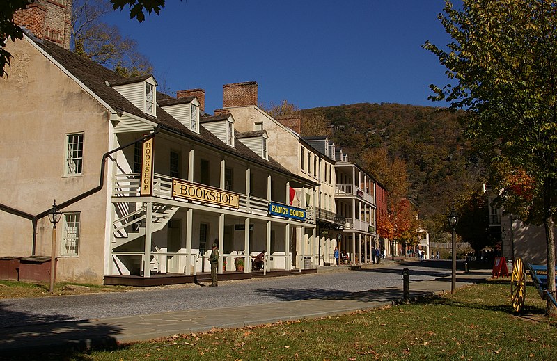
Harpers Ferry National Historical Park (added 1966 - - #66000041)
At confluence of Shenandoah and Potomac rivers , Harpers Ferry
Missvain, CC BY-SA 3.0, via Wikimedia Commons
Historic Significance:
Information Potential, Person, Architecture/Engineering, Event
Architectural Style:
No Style Listed
Historic Person:
Brown,John
Significant Year:
1859, 1802
Area of Significance:
Commerce, Military, Historic - Non-Aboriginal, Politics/Government, Invention, Industry, Social History, Architecture
Cultural Affiliation:
American
Period of Significance:
1850-1874, 1825-1849, 1800-1824, 1750-1799
Owner:
Federal
Historic Function:
Defense, Domestic, Industry/Processing/Extraction, Transportation
Historic Sub-function:
Battle Site, Fortification, Manufacturing Facility, Single Dwelling
Current Function:
Domestic, Education, Landscape, Recreation And Culture
Current Sub-function:
College, Institutional Housing, Monument/Marker, Museum
Hillsboro Historic District (added 1979 - - #79003049)
VA 9 , Hillsboro
Strawser, CC BY-SA 3.0, via Wikimedia Commons
Historic Significance:
Event, Architecture/Engineering
Architect, builder, or engineer:
Unknown
Architectural Style:
Federal
Area of Significance:
Agriculture, Architecture, Community Planning And Development, Commerce
Period of Significance:
1875-1899, 1850-1874, 1825-1849, 1800-1824, 1750-1799
Owner:
Local, Private
Historic Function:
Domestic
Historic Sub-function:
Single Dwelling
Current Function:
Domestic
Current Sub-function:
Single Dwelling
Hillsboro Historic District (Boundary Increase) (added 2010 - - #09000921)
Charles Town Pike, between Hillsboro Rd. and Stony Point Rd. , Hillsboro
send us a photo to share
Historic Significance:
Event, Architecture/Engineering
Architectural Style:
Queen Anne, Federal
Area of Significance:
Commerce, Architecture
Period of Significance:
1925-1949, 1900-1924, 1875-1899, 1850-1874, 1825-1849, 1800-1824, 1750-1799, 1700-1749
Owner:
Private, Local
Historic Function:
Commerce/Trade, Domestic, Domestic, Education, Government, Industry/Processing/Extraction, Religion
Historic Sub-function:
Manufacturing Facility, Post Office, Religious Structure, School, Secondary Structure, Single Dwelling, Specialty Store
Current Function:
Agriculture/Subsistence, Commerce/Trade, Domestic, Domestic, Education, Social
Current Sub-function:
Agricultural Fields, Meeting Hall, School, Secondary Structure, Single Dwelling, Specialty Store
Hillsboro Historic District Updated Nomination and Boundary Increase (added 2010 - - #10000091)
Also known as VDHR File Number 236-0040
Charles Town Pk., between Hillsboro Rd. and Stony Pt. Rd. , Hillsboro
send us a photo to share
Historic Significance:
Event, Architecture/Engineering
Architectural Style:
Queen Anne, Federal
Area of Significance:
Commerce, Architecture
Period of Significance:
1925-1949, 1900-1924, 1875-1899, 1850-1874, 1825-1849, 1800-1824, 1750-1799, 1700-1749
Owner:
Local, Private
Historic Function:
Commerce/Trade, Domestic, Education, Government, Industry/Processing/Extraction, Religion, Transportation
Historic Sub-function:
Manufacturing Facility, Post Office, Religious Structure, Road-Related, School, Single Dwelling, Specialty Store
Current Function:
Agriculture/Subsistence, Commerce/Trade, Domestic, Education, Social
Current Sub-function:
Agricultural Fields, Meeting Hall, School, Secondary Structure, Single Dwelling, Specialty Store
Leesburg Historic District (added 1970 - - #70000807)
Area of the original town centered at jct. of U.S. 15 and VA 9 , Leesburg
Strawser, CC BY-SA 3.0, via Wikimedia Commons
Historic Significance:
Architecture/Engineering
Architect, builder, or engineer:
Unknown
Architectural Style:
Classical Revival, Greek Revival
Area of Significance:
Architecture
Period of Significance:
1875-1899, 1825-1849, 1800-1824, 1750-1799
Owner:
Local, Private
Historic Function:
Commerce/Trade, Domestic, Government
Current Function:
Commerce/Trade, Domestic, Government
Leesburg Historic District (Boundary Increase) (added 2002 - - #02000531)
Roughly bounded by North, Union Sts., Morven park Rd., and Harrison St. , Leesburg
send us a photo to share
Historic Significance:
Architecture/Engineering, Event
Architect, builder, or engineer:
French, Daniel, III, et al.
Architectural Style:
Georgian, Other
Area of Significance:
Architecture, Community Planning And Development
Period of Significance:
1950-1974, 1925-1949, 1900-1924, 1875-1899, 1850-1874, 1825-1849, 1800-1824, 1750-1799
Owner:
Private
Historic Function:
Commerce/Trade, Domestic, Education, Funerary, Government, Religion, Social
Historic Sub-function:
Department Store, Financial Institution, Government Office, Hotel, Multiple Dwelling, Restaurant, Single Dwelling
Current Function:
Commerce/Trade, Domestic, Education, Funerary, Government, Religion, Social
Current Sub-function:
Department Store, Financial Institution, Hotel, Meeting Hall, Multiple Dwelling, Restaurant, Single Dwelling
Llangollen (added 2017 - - #100001497)
21515 Trappe Road, Upperville
KLOTZPLATE, CC BY-SA 4.0, via Wikimedia Commons
Historic Significance:
Event, Architecture/Engineering
Architectural Style:
Colonial, Other
Area of Significance:
Architecture, Agriculture, Entertainment/Recreation
Period of Significance:
1795-1967 AD
Lovettsville Historic District (added 2012 - - #12000518)
Roughly N. & S. Berlin Pike, E. Broad Way, S. Light, S. Locust, & S. Loudoun Sts., Lovettsville Rd., Lovettsville
Acroterion, CC BY-SA 3.0, via Wikimedia Commons
Historic Significance:
Event, Architecture/Engineering
Architectural Style:
Late Victorian, Bungalow/Craftsman
Area of Significance:
Architecture, Exploration/Settlement, Commerce, Black, European, Politics/Government
Period of Significance:
1950-1974, 1925-1949, 1900-1924, 1875-1899, 1850-1874, 1825-1849, 1800-1824, 1750-1799
Middleburg Historic District (added 1982 - - #82001823)
US 50, VA 626 and 776 , Middleburg
Strawser, CC BY-SA 3.0, via Wikimedia Commons
Historic Significance:
Person, Event, Architecture/Engineering
Architect, builder, or engineer:
Multiple
Architectural Style:
Federal, Other, Late 19th And 20th Century Revivals
Historic Person:
Powell, Burr
Significant Year:
1787
Area of Significance:
Politics/Government, Military, Architecture, Commerce, Transportation, Community Planning And Development, Other, Religion
Period of Significance:
1900-1924, 1875-1899, 1850-1874, 1825-1849, 1800-1824, 1750-1799
Owner:
Local, Private
Historic Function:
Commerce/Trade, Domestic, Education, Religion
Historic Sub-function:
Religious Structure, School
Current Function:
Commerce/Trade, Domestic, Education, Religion
Current Sub-function:
Religious Structure, School
Murray Hill (added 2014 - - #14000945)
Leesburg, Leesburg
KLOTZ, CC BY-SA 4.0, via Wikimedia Commons
Oakham Farm (added 2016 - - #15001039)
Middleburg, Middleburg
KLOTZPLATE, CC BY-SA 4.0, via Wikimedia Commons
Historic Significance:
Event, Architecture/Engineering
Architectural Style:
Mixed (More Than 2 Styles From Different Periods), Greek Revival
Area of Significance:
Military, Architecture
Period of Significance:
1790-1940 AD
Oatlands Historic District (added 1974 - - #74002327)
Also known as See Also:Oatlands
S of Leesburg off U.S. 15 , Leesburg
Acroterion, CC BY-SA 3.0, via Wikimedia Commons
Historic Significance:
Event, Information Potential, Architecture/Engineering
Architect, builder, or engineer:
Unknown
Architectural Style:
No Style Listed
Area of Significance:
Historic - Non-Aboriginal, Agriculture, Architecture, Commerce, Landscape Architecture
Cultural Affiliation:
Industrial,American
Period of Significance:
1875-1899, 1850-1874, 1825-1849, 1800-1824
Owner:
Private
Historic Function:
Agriculture/Subsistence, Education, Industry/Processing/Extraction, Religion
Historic Sub-function:
Manufacturing Facility, Processing, Religious Structure, School
Current Function:
Agriculture/Subsistence, Domestic, Recreation And Culture
Current Sub-function:
Museum, Village Site
Paeonian Springs Historic District (added 2006 - - #06000352)
Also known as VDHR #053-5072
Area inc. parts of Berry Bramble Ln., Catoctin Ridge St., Charles Town Pike, Highland Circle, and Simpson Circle , Paeonian Springs
KLOTZ, CC BY-SA 3.0, via Wikimedia Commons
Historic Significance:
Event, Architecture/Engineering
Architectural Style:
Late 19th And 20th Century Revivals, Late Victorian
Area of Significance:
Architecture, Social History
Period of Significance:
1950-1974, 1925-1949, 1900-1924, 1875-1899
Owner:
Local, Private
Historic Function:
Commerce/Trade, Domestic, Education, Health Care
Historic Sub-function:
Department Store, Hotel, Resort, School, Secondary Structure, Single Dwelling
Current Function:
Domestic, Government
Current Sub-function:
Post Office, Secondary Structure, Single Dwelling
Purcellville Historic District (added 2007 - - #07000277)
Also known as DHR #286-5001
Roughly bounded by W&OD Trail, S. 32nd St., W. F and E. G Sts., and Maple Ave. , Purcellville
Strawser, CC BY-SA 3.0, via Wikimedia Commons
Historic Significance:
Architecture/Engineering, Event
Architect, builder, or engineer:
Simpson, Arch, et.al.
Architectural Style:
Late 19th And Early 20th Century American Movements, Late Victorian
Area of Significance:
Community Planning And Development, Commerce, Transportation, Architecture
Period of Significance:
1950-1974, 1925-1949, 1900-1924, 1875-1899, 1850-1874, 1825-1849
Owner:
Local, Private
Historic Function:
Commerce/Trade, Domestic, Education, Social, Transportation
Historic Sub-function:
Financial Institution, Library, Meeting Hall, Rail-Related, Single Dwelling
Current Function:
Commerce/Trade, Domestic, Education, Recreation And Culture, Religion
Current Sub-function:
Library, Multiple Dwelling, Outdoor Recreation, Religious Structure, Restaurant, Single Dwelling, Specialty Store
Rock Hill Farm (added 2009 - - #09000664)
Also known as VDHR File No. 053-1057
20775 Airmont Rd. , Bluemont
KLOTZ, CC BY-SA 3.0, via Wikimedia Commons
Historic Significance:
Architecture/Engineering
Architectural Style:
Federal
Area of Significance:
Architecture
Period of Significance:
1950-1974, 1925-1949, 1900-1924, 1875-1899, 1850-1874, 1825-1849, 1800-1824, 1750-1799
Owner:
Private
Historic Function:
Agriculture/Subsistence, Domestic, Funerary
Historic Sub-function:
Agricultural Outbuildings, Cemetery, Single Dwelling
Current Function:
Agriculture/Subsistence, Domestic, Funerary
Current Sub-function:
Agricultural Outbuildings, Mortuary, Single Dwelling
Stoke (added 2015 - - #15000878)
Aldie, Aldie
Nyttend, Public domain, via Wikimedia Commons
Historic Significance:
Person, Architecture/Engineering
Architectural Style:
Greek Revival, Renaissance
Historic Person:
Harris, Eleanor Truax
Area of Significance:
Architecture, Agriculture
Period of Significance:
1800-1949 AD
Taylorstown Historic District (added 1978 - - #78003027)
Around jct. of Rtes. 633 and 688 at Catoctin Creek , Taylorstown
Acroterion, CC BY-SA 3.0, via Wikimedia Commons
Historic Significance:
Event, Architecture/Engineering
Architect, builder, or engineer:
Unknown
Architectural Style:
No Style Listed
Area of Significance:
Commerce, Architecture
Period of Significance:
1900-1924, 1875-1899, 1850-1874, 1825-1849, 1800-1824, 1750-1799, 1700-1749
Owner:
Private
Historic Function:
Domestic, Industry/Processing/Extraction
Historic Sub-function:
Manufacturing Facility, Single Dwelling
Current Function:
Domestic
Current Sub-function:
Single Dwelling
Taylorstown Historic District (Boundary Increase) (added 2005 - - #05000474)
Also known as 053-0603
13122 Furnace Mountain, 13090 Taylorstown, 12969 Taylorstown, 12995 Hoysville, and 13000 Hoysvile Rds. , Taylorstown
send us a photo to share
Historic Significance:
Architecture/Engineering
Architectural Style:
Other, Gothic Revival
Area of Significance:
Architecture
Period of Significance:
1950-1974, 1925-1949, 1900-1924, 1875-1899, 1850-1874, 1825-1849, 1800-1824, 1750-1799, 1700-1749
Owner:
Private
Historic Function:
Agriculture/Subsistence, Commerce/Trade, Domestic
Historic Sub-function:
Animal Facility, Department Store, Secondary Structure, Single Dwelling
Current Function:
Agriculture/Subsistence, Commerce/Trade, Domestic
Current Sub-function:
Animal Facility, Department Store, Secondary Structure, Single Dwelling
Temple Hall (added 2007 - - #07000053)
Also known as Temple Hall Farm Regional Park, VDHR File No. 053-0303
15764 Temple Hall Ln. , Leesburg
Strawser, CC BY-SA 3.0, via Wikimedia Commons
Historic Significance:
Architecture/Engineering, Event
Architect, builder, or engineer:
Mason, William Temple Thompson
Architectural Style:
Federal
Area of Significance:
Architecture, Agriculture
Period of Significance:
1950-1974, 1925-1949, 1900-1924, 1875-1899, 1850-1874, 1825-1849, 1800-1824
Owner:
Local
Historic Function:
Agriculture/Subsistence, Domestic
Historic Sub-function:
Agricultural Fields, Agricultural Outbuildings, Animal Facility, Processing, Secondary Structure, Single Dwelling, Storage
Current Function:
Agriculture/Subsistence, Domestic, Landscape, Recreation And Culture
Current Sub-function:
Agricultural Fields, Natural Feature, Outdoor Recreation, Parking Lot, Secondary Structure, Single Dwelling, Storage
Unison Battlefield Historic District (added 2011 - - #11000835)
Parts of Quaker Ln., Jeb Stuart, Unison, Newlin Mill, Millville, Bloomfield, Welbourne, Greengarden Rds., Unison
Cecouchman, CC BY-SA 3.0, via Wikimedia Commons
Historic Significance:
Event, Information Potential
Area of Significance:
Military, Historic - Non-Aboriginal
Period of Significance:
1850-1874
Unison Historic District (added 2003 - - #03000442)
Also known as 53-692
Area including parts of Unison and Bloomfield Rds. , Middleburg
KLOTZ, CC BY-SA 3.0, via Wikimedia Commons
Historic Significance:
Architecture/Engineering
Architectural Style:
Federal, Greek Revival
Area of Significance:
Architecture
Period of Significance:
1950-1974, 1925-1949, 1900-1924, 1875-1899, 1850-1874, 1825-1849, 1800-1824
Owner:
Private
Historic Function:
Agriculture/Subsistence, Commerce/Trade, Domestic, Education, Religion
Historic Sub-function:
Agricultural Outbuildings, Religious Structure, School, Secondary Structure, Single Dwelling, Specialty Store
Current Function:
Agriculture/Subsistence, Commerce/Trade, Domestic, Religion
Current Sub-function:
Agricultural Outbuildings, Religious Structure, Secondary Structure, Single Dwelling, Specialty Store
Vestal's Gap Road and Lanesville Historic District (added 2000 - - #99001722)
Also known as 53-0498, 53-0007
21544 Cascades Pkwy. , Sterling
KLOTZ, CC BY-SA 4.0, via Wikimedia Commons
Historic Significance:
Event, Architecture/Engineering
Architectural Style:
Early Republic
Area of Significance:
Architecture, Transportation
Period of Significance:
1800-1824, 1750-1799, 1700-1749
Owner:
Local
Historic Function:
Commerce/Trade, Domestic, Government, Transportation
Historic Sub-function:
Post Office, Restaurant, Road-Related, Single Dwelling
Current Function:
Landscape, Recreation And Culture
Current Sub-function:
Outdoor Recreation, Park
Waterford Historic District (added 1969 - - #69000256)
Also known as Waterford
NW of Leesburg on Rte. 665 , Waterford
Acroterion, CC BY-SA 3.0, via Wikimedia Commons
Historic Significance:
Event, Architecture/Engineering
Architect, builder, or engineer:
Unknown
Architectural Style:
No Style Listed
Area of Significance:
Exploration/Settlement, Architecture, Commerce, Religion
Period of Significance:
1875-1899, 1850-1874, 1825-1849, 1800-1824, 1750-1799, 1700-1749
Owner:
Local, Private
Historic Function:
Domestic, Industry/Processing/Extraction
Historic Sub-function:
Manufacturing Facility, Single Dwelling
Current Function:
Domestic, Industry/Processing/Extraction
Current Sub-function:
Manufacturing Facility, Single Dwelling
Willisville Historic District (added 2019 - - #100004746)
Middleburg, Middleburg
Ser Amantio di Nicolao, CC BY-SA 4.0, via Wikimedia Commons
Historic Significance:
Event, Architecture/Engineering
Architectural Style:
Mixed (More Than 2 Styles From Different Periods), Late 19th And Early 20th Century American Movements
Area of Significance:
Black, Ethnic Heritage
Period of Significance:
1840-1959 AD
Return to Top
Select a Different Virginia County (map)
Accomack
Albemarle
Alexandria
Alleghany
Amherst
Appomattox
Arlington
Augusta
Bath
Bedford
Botetourt
Bristol
Brunswick
Buckingham
Buena Vista
Campbell
Caroline
Carroll
Charles City
Charlotte
Charlottesville
Chesapeake
Chesterfield
Clarke
Colonial Heights
Covington
Craig
Culpeper
Cumberland
Danville
Dinwiddie
Emporia
Essex
Fairfax
Fauquier
Floyd
Fluvanna
Franklin
Frederick
Fredericksburg
Galax
Giles
Gloucester
Goochland
Grayson
Greene
Halifax
Hampton
Hanover
Harrisonburg
Henrico
Henry
Highland
Hopewell
Isle Of Wight
James City
King And Queen
King George
King William
Lancaster
Lee
Lexington
Loudoun
Louisa
Lunenburg
Lynchburg
Madison
Manassas
Martinsville
Mathews
Mecklenburg
Middlesex
Montgomery
Nelson
New Kent
Newport News
Norfolk
Northampton
Northumberland
Nottoway
Orange
Page
Patrick
Petersburg
Pittsylvania
Portsmouth
Powhatan
Prince Edward
Prince George
Prince William
Pulaski
Radford
Rappahannock
Richmond
Roanoke
Rockbridge
Rockingham
Russell
Salem
Scott
Shenandoah
Smyth
Southampton
Spotsylvania
Stafford
Staunton
Suffolk
Surry
Sussex
Tazewell
Virginia Beach
Warren
Washington
Waynesboro
Westmoreland
Williamsburg
Winchester
Wise
Wythe
York
Select a Different State (map)
Alabama
Alaska
Arizona
Arkansas
California
Colorado
Connecticut
Delaware
District Of Columbia
Florida
Georgia
Hawaii
Idaho
Illinois
Indiana
Iowa
Kansas
Kentucky
Louisiana
Maine
Maryland
Massachusetts
Michigan
Minnesota
Mississippi
Missouri
Montana
Nebraska
Nevada
New Hampshire
New Jersey
New Mexico
New York
North Carolina
North Dakota
Ohio
Oklahoma
Oregon
Pennsylvania
Rhode Island
South Carolina
South Dakota
Tennessee
Texas
Utah
Vermont
Virginia
Washington
West Virginia
Wisconsin
Wyoming
Return to Home Page